By Richard C. Lewis, IowaNow

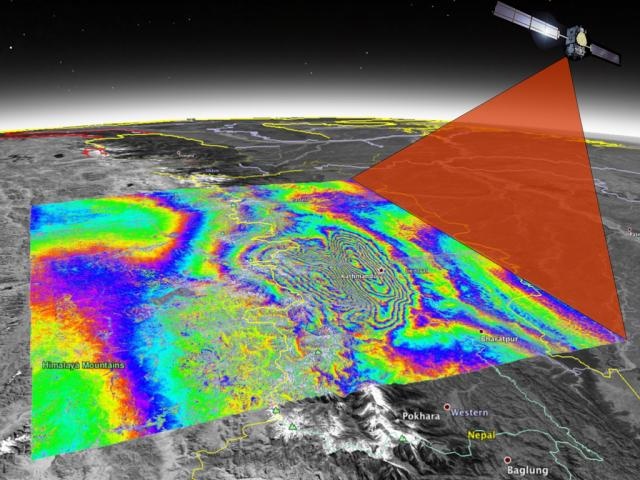
University of Iowa researchers are using ground and satellite instruments to construct a detailed map of the region affected by the earthquake that struck Nepal in 2015. This type of earthquake, called a megathrust earthquake, is among the most devastating to occur on Earth, but they’re difficult to study because they mostly occur under oceans. Photo courtesy of Bill Barnhart lab, University of Iowa.
The day after Christmas in 2004, an undersea earthquake occurred near the Indonesian island of Sumatra, triggering 30-foot waves that roiled the Indian Ocean as far as East Africa and killed at least 225,000 people in a dozen countries.
In 2011, an immense underwater earthquake shook Japan, triggering a tsunami that destroyed the Fukushima nuclear reactor and decimated a large swath of the country’s eastern coast.
While earthquakes are common, some, like the megathrust quakes off Indonesia and Japan, are particularly devastating.
“On a global scale, they produce the Earth’s largest earthquakes because they occur along the Earth’s largest faults,” says Bill Barnhart, an earthquake specialist at the University of Iowa.
Barnhart is studying megathrust earthquakes by examining the largest one this century that took place entirely on land, the megathrust quake that struck Nepal in 2015. With funding from the U.S. National Science Foundation, Barnhart and his research team, along with collaborators from the University of Colorado Boulder, will use satellite imagery, ground seismometers, and GPS stations to map the Gorkha megathrust quake and gain greater insights into why it occurred.
Researchers seek to answer many questions.
A central issue is to understand subduction zones that trigger megathrust quakes. Subduction occurs where one tectonic plate slides beneath another, causing slippage and scraping that ripples through the Earth’s interior. With the Gorkha earthquake, the Indian and Eurasian continental plates collided, spawning two major temblors that leveled much of Nepal’s capital city, Kathmandu. Those quakes registered 7.8 and 7.3 on the Earthquake Moment Magnitude scale.